Well, I've been trying to find some archive images of Murton Lane - to see if those old Open lanterns would appear. Sadly, there seems to be no photos at all - and is not helped because there is actually another place called Murton/Murton Lane and was a railway station, just like the York one! Murton Lane used to have a level crossing as part of the Derwent Valley light Railway (a route that operated from Layerthorpe in York to Cliffe Common near Selby, via Tang Hall, Osbaldwick, Murton, Dunnington, Elvington (now the airfield area), Wheldrake, Thorganby, Skipwith... and then I lose track) and the DVLR itself connected with the Foss Islands branch line that went from the scarborough line 'burton lane' junction (where the B1363 wigginton road and Crichton Avenue join) to Foss Islands Road, via the Rowntrees factory. The Foss Islands Branch is now a cycle track, as is part of the DVLR from Foss Islands to Osbaldwick.
Anyway, it is my belief that the Open lanterns at Murton were used to illuminate the roadway on the approach to the level crossing - and so when the railway closed in the 1980's, the lanterns were never serviced thereafter. Should this be the case, the tungsten lamp that can be seen in lantern #2 is getting on for 30 years old.
For those interested, here's the original route timetable for the DVLR
http://www.dvlr.org.uk/DVLRtimetable.htmAnd this is the water tower at the Foss Islands terminus. The scene is unrecogniseable today, although that house on the far right of the picture by the water tower still exists. The bridge behind the wood shed (with the gas tower in the backgound) existed until about 3-5 years ago.
http://www.dvlr.org.uk/H1.htmand another view, in colour from 1984. the line that curves away to the left is the exact line that the cycle path now follows after it crosses the re-routed Hallfield Lane. the two arrow-straight lines originally went to sidings that supplied various industrial places, including the Incinerator (now the site of Morrisons, but the old chimney still stands proud) and york's power station (there used to be a cooling tower on what is now government offices called Kings Pool - or it was until some local nicked the 'L' from the name sign outside the entrance!).
The funny thing is, looking at this picture, I can actually remember this scene! It stayed with these rail lines in place for a few years until the mid-late 1990's - the cycle path only went to Hallfield Road, and then you had to cycle along the roads through 5th avenue and onto the converted DVLR section a few hundred yards further up. After the tracks were pulled, this area just remained a boggy area of ash and ballast mixed in - and for a while was a playground for chavs with motorbikes.
http://www.flickr.com/photos/79893903@N ... otostream/an aerial view of the Murton Lane area - less than a mile of the original rail route has been preserved, but sadly does not include the Murton Lane level crossing. if you follow the line of the railway over the road, you will see a telegraph pole that would have originally stood on the 'murton side' of the level crossing - this is where open lantern #2 is situated
http://www.dvlr.org.uk/a4.htmosbaldwick siding, and I see an old fluorescent platform lantern
http://www.flickr.com/photos/79893903@N00/1230670720Other rail-related pics worth a look....
Strensall (north) level crossing, with an old DMU. This is the level crossing you get to if you go up Flaxton Lane for a while.
http://www.flickr.com/photos/pinzac55/3284950195/Bootham signalbox. this stood at the east end of the level crossing with the B1363 wigginton road. if you look to the back of the train, you can see a line diverge off to the right - this was the start of the route to Beverley via Huntington, Stamford Bridge, Pocklington and Market Weighton
http://www.flickr.com/photos/pinzac55/3284937705/the signalbox
http://www.flickr.com/photos/pinzac55/3285732944/Burton Lane signalbox. This stood at the end of Field Lane, which comes off Burton Stone Lane. Basically, all the buildings except the signalbox are still standing. this box controlled access to the foss islands branch, and by extension the DVLR i it was used for trains to selby on a divert route...
But what is the post top lantern in the background (between the signalbox and the sewer pipe)?? nowadays, a WRTL 2000 stands there.
http://www.flickr.com/photos/pinzac55/3284632702/Haxby Road signalbox. This was on the road to New Earswick. the scene today is very different, as it is now a mini-roundabout (where I got knocked off my bike by somebody who didn't know how to properly look right). the trees and fields in the background have gone, as houses were built when the village was extended. If you want to see crossing gates like this in use, then go to Redcar.
http://www.flickr.com/photos/pinzac55/3284621682/Haxby signalbox, Towthorpe Road. This is at the north end of Haxby, and the fuel garage behind the signal box still stands, as do most of the houses. And that's a rather nice Eleco Way HW828 lantern in show too! (even if that had survived until recently, it would now have a Jet on the end. In reality though I believe it has a WRTL 200 on it)
http://www.flickr.com/photos/pinzac55/3283796327/--
Selby Swingbridge, with a high river level.... this was back in the days that Selby was part of the east coast main line
http://www.flickr.com/photos/pinzac55/3276989610/... and the only reason for me linking to this picture is the sheer comedy value of the name!
http://www.flickr.com/photos/pinzac55/3276802014/--
old york pics.
Walmgate bar, and there are 2 gas lanterns in view
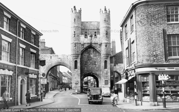
http://images.francisfrith.com/c10/450/46/18448.jpgMonk Bar in 1955. Just above the signpost for the A19 (where the watermark is, bottom right) you can see a wall bracket with a lantern of some description fitted. Note the abscence of wall mounted lanterns by the Monk Bar itself. two lanterns would be installed (both on the pub wall to the left, and on a building to the right of the bar) on wall brackets about 5 years later - which I now know were GEC Z8432's (or whatever it is I have). I do have a later picture of Monk Bar with said lanterns installed
http://images.francisfrith.com/c10/450/46/Y12044.jpgpictures are from this page, if they are not loading
http://www.francisfrith.com/wigginton,north-yorkshire/FInally, a now outdated image. this is Claygate, Ashley Park area of Heworth.
http://www.flickr.com/photos/79893903@N00/4392224474/That metal canopied GEC Z5670 has long gone, and now a Jet stands there. I do have 4 full metal top Z5670's with an additional 4 metal canopies, so there is the off chance that this lantern is oen that I have saved (either in whole or in part).... I'm going to go with the outcome that I have saved this lantern, as it just feels nice!


